Monday, November 5, 2018

Banjosa Lake Rawalakot | Pakistan


Pakistan Tourist Attraction Place at Banjosa Lake Rawalakot

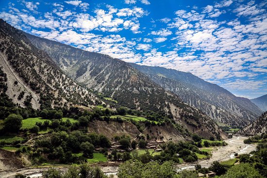
It is one of the most beautiful valleys of Azad Kashmir with captivating waterfalls and spectacular views. Rawlakot has an Agriculture University and several other colleges and secondary educational institutes. It is famous for trekking, hiking, paragliding and water based activities. This place expects a high number of tourists during peak times.

Banjosa lake is a very overrated place. Lake is artificial and not scenic at all also water is quite dirty. The place is very over crowded by local visitors. Road towards lake is quite bad in shape.

Rawalakot is a valley situated in the heart of district Poonch of Azad Jammu and Kashmir. It is shaped like a saucer with an altitude of 1615 meters. It is accessible through Islamabad by a three and a half hour long drive. The weather in the valley stays cold throughout the year with an average temperature of 20°C in summers.


Its one of the mesmerizing lakes in Azad Kashmir. The lake is surrounded by mountains all around. This gives the lake a beautiful greenish shade. Boating option is available. Number of restaurants are available here, so one can find different food varieties. Also nearby rest houses and hotels are available if someone want to stay for a night. If somebody likes to take a stroll trough woods around the lake, its a good option as well. 

Note, P.S: Please don't put everything on the authorities. We as a people also need to take care for the cleanliness of lake and surroundings. Its a beautiful place and lets keep it that way.

Kalam Valley Swat | Best Pakistan Tourist Place


Kalam Valley Swat | Best Pakistan Tourist Place

Kalam is a tourist attraction nestled into the Swat Valley of Pakistan. With the nearby mountains and rivers surrounding it, Kalam holds many things for visitors to do.

"Queen Elizabeth II during her visit to Swat State in 1961 rightly called it the Switzerland of the East as Swat is an abode of high mountains, green meadows, tall waterfalls and clear lakes."

Kalam Valley is famous for its magnificent waterfalls, lakes and lush green hills. It is 270 km drive from Islamabad, the capital of Pakistan. It is one of the popular destinations for tourists. At 29 kilometers (18 mi) from Bahrain and about 2,000 meters (6,800 ft) above sea level, the valley opens out, providing rooms for a small but lush plateau above the river.

Kundal Lake is surrounded by mountains and pristine views. It is typically reached by trekking about three hours from Kalam. It is highly advisable to take a guide, since you have to follow a branch of the Swat River.You can also reach Laddu Valley, the site of Kundal Lake, by jeep.

The valley offers every luxury to nature lovers and adventure seekers, however, to explore its over 50 glacial lakes one has to trek on the narrow bends and steep cliffs.

Naltar Lake Gilgit Baltistan | Best Place Ever


Naltar Lake Gilgit Baltistan | Best Place Ever in Pakistan

I have no other choice as it’s an official visit, why are you going there?” Someone asked me at Naltar Ada, Gilgit while waiting for the Jeep. I tried to convince him that I have heard a lot about Naltar Valley and I believe it would be a life time experience, the guy laughed “Yes, it would be a life time.

This is the first of two lakes. Food and facilities are available at both. We took jeeps from Rahimabad at Rs7000 each. It is about a 2.5 hour journey each way from there (little less on the way back). The way is also beautiful. Jeeps are available form Nomal too but did not check prices there (should be cheaper as closer).

Naltar Valley is situated in the north-west of Gilgit-Baltistan the 5th province of Pakistan (The Doorway of the World) and (The Township of the mountains). It is 40 km (25 mi) from Gilgit city across the nomal valley and its evolution is about 4,678 m (15,348 ft.).Naltar valley is well known for its beauty and it’s hi lakes. It is the most visiting area for the travelers across silk road, KKH( Karakorum highway) and now CEPC(China Pakistan economic corridor). People said it is the true paradise. That’s why every year more than fifty thousand visitors came to see its beauty and enjoy their summer holidays season.

We explored Naltar Valley with Royal's Adventure Club in summers. Naltar valley is accssible in summers and winters both.

Summer Attractions: 
- Naltar Valley 
- Satrangi Lake 
- Blue Lake
- Snow Leopard 
- Jeep Safari 
- Mesmerizing views of the mountains


Winter Attractions: 
- Skiing 
- Naltar Valley 
- Snowfall 
- Photography 
- Jeep Safari Adventure

Several trees grow along the trail with large shrubs running along each side of the route from Chillam to Astore. The course is just like any other mountainous route — uneven and bumpy. Passing through small towns and villages on the flank of the mountain, one can see a stream of ice-cold water gushing out from Deosai.

Tuesday, September 25, 2018

Hunza Valley, Gilgit Baltistan


Hunza Valley, Gilgit Baltistan

Every traveller must fall in love with the area at first sight. There is nothing better than to get to Karimabad (2420 m asl), the heart of the Hunza valley, after a difficult and long trek, sit on the terrace of one of the small hotels, pluck ripe apricots directly from the tree and enjoy the breathtaking sunsets at the local mountain queen – Rakaposhi (7788 m asl).

The magnificent Attabaad Lake, which is also known as Gojal Lake is situated in Gojal Valley of Gilgit Baltistan. There is a sad fact that a lot of Pakistanis don’t know about the lake, It was formed in January 2010 after a massive land sliding into the Hunza River.

Hunza river broke here through the ridge of the mighty Karakoram, which is more than five kilometers higher, so there are plenty of dramatic views in all directions.


Borith lake is situated just 2-3 KM away from KKH, The road towards lake is a mud track but could be reached with cars easily. The color of lake is very dark and may be not as beautiful with respect to other lakes of Gilgit Baltistan but its water is crystal clear. The place is very silent and peaceful and sight is also very scenic.

Satpara Lake Sakardu, Pakistan


Satpara Lake Sakardu, Pakistan

Satpara Lake (also called “Sadpara Lake”) is natural lake situated about 9 kilometers (5.59 miles) north of Skardu (the capital of Baltistan), in Gilgit-Baltistan region of Pakistan. Situated at an altitude of 2,635 meters (8645 feet) the lake is reached after 20 minutes of jeep drive from Skardu.

A dam named as Skardu Dam is being built on this lake to generate more electricity. The dam is 128 ft high and will generate about 17.36 MV of electricity. The lake is a big source of fresh water and is 8650 ft long. The crystal clear water of Satpara Lake gives delight to one’s eyes. The water of this lake shines in the daytime and that is why people believe that gold is buried in the bottom. Satpara Lake serves as a centre of various activities such as row borating, and trout fishing.


The lake is open the whole year but this does not mean that the optimal time to travel to the lake is anywhere in the summer or the winter months. Rather the best time to travel to the lake is in the spring when the lush vegetation near the lake has taken full form and the flowers have started to bloom. With the vegetation growing and the flowers blooming, the vast lake which measures more than 2.5 Km becomes a marvel of nature. And as the dam has added more space to the lake, this time is the best time to see various animals that have now made their homes near the lake in order to reap the benefits that it brings.

After visiting some of Pakistans smaller Lakes I found this Lake still beautiful but not as captivating as the others. I don't know if it was due to the weather or just the size of the Lake. It didn't matter as we were going past it anyway and we enjoyed stopping to take a few photos. Like usual I find the colour of the water contrasts beautifully with the harsher landscape.

Katas Raj Temple, Ancient history

Related image

Katas Raj Temple, Ancient history
Situated within embrace of the Salt Range near Kallar Kahar, Punjab, this splendid complex of temples dedicated to Ram, Hanuman and Shiva is laid around a natural pond. The pond, the faithful believe, was created from a teardrop of the weeping Shiva as he flew across the sky carrying the dead body of his wife Sati.

The Katas site houses the Satgraha or seven temples, a gathering of seven old temple, remains of a Buddhist stupa, a couple of medieval sanctuaries, havelis and some as the newly built sanctuaries, scattered around a lake considered sacred by Hindus.

 He shed two tears, one creating this pond, the other falling and making a pond in Ajmer, Rajasthan. The Pandavas came to this place during their exile, the legend goes, and built some of the older temples. Historical records suggest many of the temples, constructed in the Kashmiri architectural tradition, came up in the 11th century CE, when this region, along with parts of Punjab, fell under a Kashmiri kingdom.

Taobat Neelam Valley, Azad Kashmir

Related image

Taobat Neelam Valley, Azad Kashmir

The last station of Neelum Valley is Taobut and end point of Pak beauty in Kashmir. It has a sever season and heavy snow in winter, and winter season continue about 6 months starting from October to April end.
It is undoubtedly the land of striking beauty, lush green rolling grounds, pine hills, wood cottages, cherry trees, meandering emerald riverine accompanying you on every turn. Seeing is believing, i just can't find any piece of territory synonymous or comparable to this amazing territory.

Accessible during spring, fall and summers, served with a metal road up to Keran, this part of valley is jeepable.


The Neelam river enter the premises of Azad Kashmir flowing down through the Taobut. It’s the very first place where we can find population while descending down the Neelam Valley along beautiful The Neelam River.

Kalash valley of Rumbur

Related image

Kalash valley of Rumbur
The Kalash valleys of Chitral are located in the southern gorges of the Hindu Kush ... Some famous Malosh sites are in Batrik, Krakal, Birir, Rumbur and Gromun.

The Kalash are found in 3 valleys Rumbur, Bumburet and Birir. They are a warrior like people who ruled from near Kabul to the Lowari Pass.

The free women of Kalash. Entering the Rumbur valley, Pakistan, with all of its violence and militancy, felt like it was left behind.

Tuesday, September 11, 2018

Gondogoro Glacier Pakistan


Gondogoro Glacier Pakistan

The view from the summit of this nearly 5700 m. pass (Gondogoro La) is beyond description. In the opinion of many, it is simply the finest mountain panorama in the world. K-2, Broad Peak, the four Gasherbrums, Trinity Peak, Laila Peak and a multitude of lesser pinnacles touch the heavens all around you.

Gondogoro Glacier is located towards the North of Hushe Valley of Gilgit Baltistan. A practically tough route of 6-7 days leading over the Gondogoro Glacier. From Skardu, a jeep road now goes right up to Hushe Village This area is located in specified restricted zone and trekking permit and permission from Ministry of Tourism, Islamabad is required. 

Gondogoro glacier is base camp for several peaks rising on the both side of the glacier can be thus reached. Famous Gondogoro Pass (5580m) is located on the north enclosing ridge of Gondogoro glacier, and by crossing this pass the Baltoro Glacier can be reached at Ali Campsite near Concordia.

The best season for this route is from the month of May to End of September each year. From Hushe village (3250m), the trail continues northwards, takes an easterly curve and, turning north again ascends the Gondogoro Glacier.


One must make an extra effort from Concordia to see this spectacle. The trek to the top of the Gondogoro La includes some 60 degree ice and snow slopes climbs that require the use of an ice axe, crampons, harness, helmet, ropes and carabiners.

The first leg of the trek takes us to Concordia (see the K-2 Trek description for this trip segment). Upon leaving Concordia we hike up to Ali Camp, situated above the Vigne Glacier. The fluted and icy-white slopes of Chogolisa tower in front of us, reminiscent of a wedding gown, which gives Chogolisa its other name: Bride Peak.

Trango Towers of Pakistan


Trango Towers of Pakistan

The Trango Towers are a set of rock towers situated in Gilgit-Baltistan, in the North of Pakistan. The Towers offer some of the largest cliffs and most challenging rock climbing in the world, and every year a number of expeditions from all corners of the globe visit Karakoram to climb the difficult granite.

Located in the Baltoro Glacier region of northern Pakistan, Great Trango, the tallest formation in Trango Valley, features 4,396 vertical feet of granite, more than any other face in the world. This spire is over 20,000 feet above sea level, and combined with Trango Tower (aka Nameless Tower) to the northwest, these formations dominate the horizon on the approach to the larger mountains of K2, Broad Peak, Gasherbrum IV, and Nanga Parbat.


Many tourists choose to travel Gilgit by air since the road travel between Islamabad and Gilgit by Karakoram Highway takes nearly 18 hours, whereas the air travel takes a mere 45-50 minutes. Gilgit Airport is located at a small ground very close to the center it takes 5 – 10 Minutes from Airport to any hotel in town.
Gilgit city is one of the two major hubs for all mountaineering expeditions almost all tourists headed for treks in Karakoram or Himalaya ranges arrive at Gilgit first. 
The best season to visit is from May to mid October. The local dialect is Shina, however, Urdu and English are also spoken and understood
Gilgit is just off the Karakoram Highway between Chilas and Karimabad, and most people arrive by road. The main bus stand is on the KKH – Karakoram Highway, and requires a taxi ride or shared jeep to reach from town. There are booking agents in town for long distance buses along the KKH. The journey from Islamabad can take as long as 24 hours.


Lake Saif ul Malook Pakistan


Lake Saif ul Malook Pakistan

Lake Saif-ul-Malook – ranked by The Guardian as the fifth best tourist destination in Pakistan – seems like heaven on earth. The greenish-blue crystal clear and freezing water, surrounded by giant glaciers, including Malika Parbat, reflects the beauty of Saif-ul-Malook.
Jheel Saiful Malook lake is located 8km away from Naran Bazar in Kaghan Valley. It takes almost 7 hours from Islamabad. Saiful Malook Lake is the most famous tourists destination in Naran Kaghan Valley. Tourists feels incomplete tour if they do not visit Lake during their Naran visit.


The magical lake is completely frozen during winters due to heavy snowfall. The ideal time for tourists starts from June to September. The weather of this divine place is extremely pleasant during day time (about 15-20 degree centigrade), whereas at night the temperature drops to three degrees centigrade.

Tuesday, September 4, 2018

Grand Canyon National Park | USA


Grand Canyon National Park

With its ever-changing and dramatic scenery of enormous proportions, the Grand Canyon is one of the world’s most spectacular landscapes. Located in northern Arizona, The Grand Canyon is one of the great tourist attractions in the United States. Its pine and fir forests, painted deserts, sandstone canyons, mesas and plateaus, volcanic and geologic features, the Colorado River, perennial streams, and waterfalls breathtakingly combine to form one of Earth’s greatest landmarks. 

Carved by the Colorado River, the canyon attains a depth of over 1.6 km (1 mile) and 446 km (277 miles) long.  The only one of the Seven Natural Wonders of the World to be located in North America, more than 4,000,000 people visit the canyon each year, making it the most visited national park in the United States. The Grand Canyon is not the deepest or the longest canyon in the world but the overwhelming size and its intricate and colorful landscape offers visitor spectacular vistas that are unmatched throughout the world. It is considered one of the Seven Natural Wonders of the World.


"Grand" doesn't begin to do this canyon justice. Measuring approximately 277 river miles in length, up to 18 miles in width and a mile deep, this massive chasm in northern Arizona is truly a natural wonder. The Grand Canyon is not the deepest or the longest canyon in the world but the overwhelming size and its intricate and colorful landscape offers visitor spectacular vistas that are unmatched throughout the world. It is considered one of the Seven Natural Wonders of the World.

For six million years, the Grand Canyon has expanded with the help of the mighty Colorado River, and for centuries, people from all over the globe have traveled to gaze out over its red and orange grandeur. 

Lake District National Park


Lake District National Park

Lake District, famous scenic region and national park in the administrative county of Cumbria, England. With 12 of the country's largest lakes and more than 2,000 miles of rights of way waiting to be explored, there's little wonder the region continues to inspire, with its magnificent views and scenery straight out of a painting. Other things to do include visiting the park's many fells, including Scafell Pike (3,210 feet), the highest mountain in England; lovely little towns and villages such as Grasmere; as well as boat excursions across Lake Windermere and Ullswater.

The Lake District became a national park in 1951, and the increased social mobility of the population of the industrial regions of northern England has stimulated the tourist industry. The increased demand for water by industrial northwestern England has resulted in the use of Thirlmere Lake as a reservoir, precluding its use for recreation.

It is the largest National Park in the country (occupying 885 sq. miles) and is considered one of its most scenic regions and England's premier destination for hiking and climbing.

Thursday, August 30, 2018

Moola Chotook in Khuzdar, Balochistan


Best Tourist Place in Pakistan at Moola Chotook in Khuzdar, Balochistan


Curiosity can be a powerful driving force; the need to constantly seek and discover. The one thing that travel does is keep your senses sharpened — you are constantly exposed to new stimuli. With every step, you are seeing, breathing and experiencing something new. And with every journey, you grow. No wonder then that some find travel to be highly addictive.


More than 100 km away from Khuzdar there is a beautiful village called Moola, It is a Tehsil of District Khuzdar. It is famous due to historical place as well as its geographical location; it is the gate way between central Baluchistan and West Baluchistan, Sindh and Iran. People opt this way (Moola Pass) because it is the shortest distance between central Baluchistan and Sindh.


The Moola Gorge, for centuries a favored route between the Kalat highlands and the fertile plains of Sindh, is a wide u-shaped, well-watered gorge. It cuts clear across the unbroken barrier of the rugged and barren Khirthar Mountains providing a travel route that could be used by ancient wheeled traffic. This paradise on Earth is in the Khuzdar District of Balochistan. Locally it is known by the name of “MOOLA CHOTOK”.

Distance To Khuzdar From Karachi is:
205 miles / 329.92 km / 178.14 nautical miles


Saturday, August 25, 2018

Faraglioni Sea Stacks on Capri Island, Italy


Faraglioni Sea Stacks off Capri Island, Italy

In Italian, faraglioni are stacks, a coastal and oceanic rock formation eroded by waves. The word may be derived from the Greek pharos or Latin pharus ("lighthouse"). They are found at the coasts of several regions of Italy and the most famous are in the Campania region, in the Bay of Naples, off the island of Capri. They are named Stella, connected to the island, (109 m), Mezzo (82 m) and Scopolo (or Fuori 106 m).

The Faraglioni are noted world-wide because of the peculiar shape and enchanting sight of them rising out of the water along the coastline. They're best seen by boat or from the beaches of Marina Piccola. These gorgeous rocks are also famous for a rare species of lizard: the "lacerta muralis coerulea" -or simply "blue lizard"- characterized by a special blue coloration that is found only on the island of Capri.

The famous three towering rock sea stacks, can only be seen from the sea at the southern part of the island. These rocks are home to the rare Blue Lizard, however he must also be elusive since nary a one was visible. When your boat passes through the famous stone archway in the middle you must kiss your partner for good luck!


A result of forceful winds and raging seas, these three Faraglioni rocks inspire countless photographers who attempt to capture their beauty. Translated, Faraglioni means “ones of the light,” and reflections of light from the azure sea create a constantly changing vision just off the Amalfi Coast and Sorrentine peninsula.


Friday, August 24, 2018

Ghizer River in Gilgit-Baltistan


Ghizer River in Gilgit-Baltistan

Ghizer River is a tributary of the Indus River, and flows past the town of Golaghmuli Valley. It is located in the Northern Areas of Gilgit–Baltistan, Pakistan. The Ghizer river starts from Shandur lake. The Ghizer River is also referred to as the Gilgit River.

June is hot, as always, and remains hot unless it rains here in Punjab. The suffocation indoors, the constant buzzing of fans, the tiny sparrows searching for water in the scorching heat, the coo-coo of quails; all the sights and sounds sadden me, and when the heat here makes it difficult to breathe, I suddenly miss the cool shades of Ghizer’s meadows.

Ghizer District is the westernmost part of the Gilgit-Baltistan region of Pakistan. Its capital is Gahkuch. Ghizer is a crossroads between Gilgit and Chitral, and also to China and Tajikistan via the Karambar Pass through Ishkomen/Darkut Yasin (which are connected via Shandur Pass).

Wednesday, August 22, 2018

Tower Bridge London | Top Tourist Attraction Place


Tower Bridge London | Top Tourist Attraction Place


One of the finest and most recognized bridges in the world, Tower Bridge is an iconic symbol of London.
As Tower Bridge is a working bridge you can visit and enjoy its historic architecture but also experience the less seldom seen opening or as it is actually known the lifting of the bridge. This lifting really is a special opportunity to experience the wonder of seeing the fully working Tower Bridge of London in all its glory.

Plans for the Tower Bridge were devised around 1876 when the east of London became extremely crowded and a bridge across the Thames in that area of the city seemed a necessity. It would take another eight years - and lots of discussions about the design - before construction of the bridge started. 
Its original color was chocolate brown, but in 1977 it was painted in red, blue and silver for the Queen´s Silver Jubilee. The bridge is situated next to the also famous London Bridge.
The bridge, designed by city architect Horace Jones in collaboration with John Wolfe Barry, would eventually be completed in 1894. Five contractors and nearly 450 workers were involved in the construction of the 265 meter long bridge. It took 11,000 tons of steel to build the framework. At the time many people disliked its Victorian Gothic design, but over time the bridge became one of London's most famous symbols.

Hiking track 5- Dara Janglan | Margala Hills


A Great View of Margala hills on Hiking track 5- Dara Janglan
The driving distance from Hiking track 5- Dara Janglan to Islamabad is 2 km. The total time spent in driving, travelling from Hiking track 5- Dara Janglan to Islamabad is 5 min. Your queried for Hiking track 5- Dara Janglan to Islamabad travel time Your Travel Time Calculations Start at Hiking track 5- Dara Janglan, Trail 5, Islamabad, Pakistan. It Ends at Islamabad, Pakistan.
Great place to hike and camp overnight. The only downside is lack of facilities like public toilet etc.

This trail is less stressful than trail 3. For the first 2 km hike is okay and even kids can do it. After that it becomes steep and only serious hikers and those fit enough should attempt it.
It saddened my heart to see that people have started spoiling this track too by leaving shoppers, wrappers etc
Though it's one of the favorite trails of many islooiets but it needs serious maintenance there are patches which have been tore out. There is only one spot on the track where one can feed benches to sit and relax which should be increased.

Monday, August 20, 2018

Neela Sandh Waterfall | Pakistan Tourist Attraction


Neela Sandh Waterfall | Pakistan Tourist Attraction
Neela Sandh waterfall is an outing spot which merits going by, not just this, this is just 38 KM far from standard Islamabad city which is just around 55 minutes drive. Be that as it may, when you reach there, you will acknowledge, you have been feeling the loss of an extremely excellent regular wonder in your patio.

Kotli Sattian is one of most beautiful village of Pakistan. In kotli Sattian a beautiful waterfall is present which called Neela Shandh. 
Neela Sandh is blue water pond on Lehtrar Road Islamabad. This beautiful waterfall is located in District Mori Syedan, Tehsil Kotli Sattian Rawalpindi. It’s almost 40 km away from capital city Islamabad. If you are a citizen of Rawalpindi or nearby area, you can have an amazing time here every weekend! This is located at 45 minutes’ drive from khanapul on Islamabad Highway. 
All things considered, Neela Sandh has the accumulation of numerous lakes, when every single common lake consolidate and stream a similar way, it turns into a lovely clean blue waterfall which really secured very nearly 12 meters territory. Those guests who adore swimming unquestionably come here to fun cool clean water with their families and companions.

Sunday, August 19, 2018

Disney World Orlando USA


Disney World Orlando USA | Tourist Attraction Point in USA
Covering nearly 47 square-miles, the Walt Disney World Resort features four theme parks: Epcot, Disney’s Animal Kingdom Park and Disney's Hollywood Studios, two water parks: Disney's Blizzard Beach and Disney's Typhoon Lagoon and over 20 resort hotels. With interactive rides, animal adventures, magical attractions, dining, shopping and nearly 60,000 cast members performing in more than 3,000 different roles, guests will be sure to feel the magic of Disney during each and every visit.
With an average of 52,964 visitors per day, the Magic Kingdom Park at the Walt Disney World Resort in Orlando, Florida remains the top-attended theme park in the world. Add to that the number of daily visitors from the other three parks owned by Disney, and the resort sees over 50 million park guests per year. It is an immortalized part of Orlando, as well as an eternal landmark for families all around the world.
With 2011 came signs of a slight upswing in the economy, tourism exhibiting the most visible signs of life. Hotels began filling rooms at a rate not seen in several years (with significant increases over the last year alone). Airport traffic and attraction attendance was on the rise, with tourists (and the theme parks) beginning to once again spend money. Disney began construction at levels almost unheard of in recent years. A major expansion began at the Magic Kingdom -- with the size of Fantasy land to be doubled by the end of this year -- and detailed plans were revealed for a re-imagined Pleasure Island, the abandoned clubs (standing empty since 2008) demolished to make way for what will soon become Hyperion Wharf. Also revealed were details regarding Disney's secretive billion-dollar investment in next-gen technology and experiences -- though sketchy (and slated to roll out over the next several years), plans include bypassing hotel check-in, reserving ride times right from your computer, and a slew of personalized interactive experiences yet to be revealed. In addition, Disney kicked off Let the Memories Begin, the resorts' latest year-long celebration that has park-goers taking center stage, their images projected on Cinderella Castle each night for all to see. Also in 2011, Discovery Cove opened the Grand Reef, expanding its lineup of underwater attractions -- including a walking tour that takes guests (donning diving helmets) along a series of underwater pathways. Even Gatorland got in on the expansion action, debuting a wild zipline experience that takes adventurous guests zipping across the park's preservelike grounds, high above the crocs and gators that lurk in the marshes below.

Yellowstone National Park | Tourist attraction


Tourist attraction at Yellow Stone National Park
Yellowstone National Park's 2 million acres are home to an incomparable combination of natural beauty, rugged wilderness, majestic peaks and abundant wildlife, as well as the world’s largest concentration of geysers and thermal features.
Established in 1872 and located primarily in Wyoming, Yellowstone National Park was America's first national park. To this day, Yellowstone remains one of the country's most popular national parks with millions of annual visitors. Yellowstone spans almost 3,500 miles, and extends into parts of Montana and Idaho, making it one of the largest national parks in the US.
"They have geysers that range from Old Faithful to these geysers that are basically holes in the ground that give a glimpse into what the bubbling boiling earth underneath is like."
As a national park, Yellowstone is open year-round. Each season provides travelers with a distinct experience ranging from wildlife-watching adventures to back country treks and fall-foliage tours to guided snowmobiling. To help you determine which time of year you'd like to explore Yellowstone National Park, we've included an overview of each season below.

Thursday, August 16, 2018

Topkapı Palace Museum

Topkapı Palace

Topkapı Palace Museum | Turkey Tourist Attraction 
It was built in 1461 by Mehmet the Conqueror and remained both the symbolic and political home of the Ottoman Empire until Sultan Abdülmecid I moved the imperial retinue to Dolmabahçe Palace in 1853. During the four centuries in between it hosted 22 different Sultans and their families.
It is located on the promontory of the historical peninsula in Ä°stanbul which overlooks both the Marmara Sea and the Ä°stanbul strait. The walls enclosing the palace grounds, the main gate on the land side and the first buildings were constructed during the time of fatih Sultan Mehmet (the Conqueror) (1451 - 81). The palace has taken its present layout with the addition of new structures in the later centuries. 
Topkapı Palace was the official residence of the Ottoman Sultans, starting with Fatih Sultan Mehmet until 1856, when Abdülmecid moved to the Dolmabahçe palace, functioned as the administrative centre of the state. The Enderun section also gained importance as a school. 
It was converted into a museum after the fall of the Ottoman Empire and the creation of the Turkish Republic in 1924 and is a must see for any tourist visiting Istanbul. It is made up of four different courtyards and various exhibitions such as the treasury, weapons, watch collection, kaftans, portraits and sacred relics of prophets.

Pilatus Switzerland | Adventurers mountains


Pilatus Switzerland | Adventurers mountains


A multi-peaked massif, Mt. Pilatus towers over Lucerne and Central Switzerland. Though Queen Victoria enlisted a mule to help her ascend the mountain in 1868, visitors now venture up by cable car or cogwheel train, which—with a gradient of up to 48 percent—is said to be one of the world’s steepest. Crisscrossed by hiking trails and sled runs, Mt. Pilatus features a kid-friendly adventure park and a suspension rope park. From the top, you can see as far as Italy on a clear day. 
In the region of Pilatus, you will find tracks not only for hikers, but for mountaineers and alpinists as well. Another very particular attraction is the longest summer-toboggan run of Switzerland - a funny and sportive experience one should not miss. At Krienser egg you find a large children's playground, a recreation area with way marked hiking trails and picnic areas with tables and benches and open barbecue.
To access the Mt. Pilatus cable car, ride the trolleybus route 1 from Lucerne’s railway station to Kriens, where you can travel to the summit station at 5,560 feet (1,695 meters) via panoramic gondola and aerial cableway. Alternatively, travel by train or ferry from Lucerne to Alpnachstad, where you can board the cogwheel railway. The Golden Round Trip can be done only during summer.

Wednesday, August 15, 2018

Buckingham Palace | Residence of Queen Elizabeth


Buckingham Palace | Residence of Queen Elizabeth 
Buckingham Palace is the London home and the administrative center of the British royal family. The enormous building and extensive gardens are an important site of ceremonial and political affairs in the United Kingdom, as well as a major tourist attraction. But for a monarchy that dates back almost a thousand years, Buckingham Palace is a relatively new home.
The palace first originated as Buckingham House, which was built by John Sheffield, 3rd Earl of Mulgrave and Marquess of Normandy, as his London residence in 1703. In the same year, Sheffield was made the Duke of Buckingham and he consequently named the house after his title.
In 1761, Buckingham House was acquired by George III, to be used as a family home for both himself and his new wife Charlotte. The ceremonial centre of the court remained at St James’s Palace, so the house was a convenient place to live. It was known as the Queen’s House, and 14 of George and Charlotte’s 15 children were born there. It was in the library of the Queen’s House that Dr Samuel Johnson had his celebrated meeting with George III. In 1762, George IV and his architect John Nash began converting the palace into a full-scale residential and ceremonial palace, using the proceeds of the land acquired from the demolition of Carlton House. A suite of rooms was added to the main block of the garden side of the house, and the side wings were demolished and replaced with grander structures to form a u-shape. The fourth side of the courtyard was enclosed by railings, with the newly-created Marble Arch monument in the centre.

Tuesday, August 14, 2018

Shoshone Water Falls | Snake River in southern Idaho


Shoshone Falls Park
When you walk up to the closest observation deck in Shoshone Falls Park, you can feel the thundering power of the “Niagara of the West” as water pours over the falls. Believe me, you will feel it shake your bones, it’s that powerful and moving of an experience.
Located at the edge of Twin Falls, Shoshone Falls is a natural beauty on the Snake River. At 212 feet, the falls are higher than Niagara Falls. The falls offer a unique blend of recreational facilities, including playgrounds, hiking trails, picnic areas, a boat ramp, swimming area, and a scenic overlook. A picnic in the shaded, grassy areas provides a perfect vantage point for viewing Shoshone Falls.
Shoshone Falls is among the most spectacular of natural beauties along the Snake River. At 212 feet, the falls are higher than Niagara Falls. They are best viewed during the spring and early summer when water flows are high – depending on winter snow melt. Irrigation diversion of Snake River flows can significantly diminish water over the falls in the summer and fall, particularly during dry years.

Statue of Liberty | New York Monument in USA


Statue of Liberty is more than a monument
The Statue of Liberty is more than a monument. She is a beloved friend, a living symbol of freedom to millions around the world. These exhibits are a tribute to the people who created her, to those who built and paid for her, to the ideals she represents, and to the hopes she inspires.

Made in Paris by the French sculptor Bartholdi, in collaboration with Gustave Eiffel (who was responsible for the steel framework), this towering monument to liberty was a gift from France on the centenary of American independence. Inaugurated in 1886, the sculpture stands at the entrance to New York Harbour and has welcomed millions of immigrants to the United States ever since.

The Statue of Liberty is perhaps New York City's most familiar landmark and the easiest one to overlook since it's only accessible by boat. This historic monument has welcomed many generations of hopeful Americans to our shores.

The Statue of Liberty exhibit, which opened in July 1986 and is located on the second floor in the pedestal of the Statue, traces the history and symbolism of the Statue of Liberty through museum objects, photographs, prints, videos and oral histories. In addition to historical artifacts and descriptive text, full scale replicas of the Statue's face and foot are also on display.   

Tokyo Disneyland | World's Most Tourism Places


Tokyo Disneyland | A theme park
Tokyo Disneyland is a theme park based on the films produced by Walt Disney. It was opened in 1983 as the first Disney theme park outside of the United States. Modeled after Disneyland in California and the Magic Kingdom in Florida, Tokyo Disneyland is made up of seven themed lands and features seasonal decorations and parades.
Disneyland is known for its awe-inspiring attractions and grand spectacles that enchant both the young and old. With a milestone being celebrated this year at its Tokyo resort, tourists can expect a whole new level of Disney magic in the coming months.
First opened in April 1983, Tokyo Disneyland is marking its 35th anniversary with "Happiest Celebration," a multitude of festivities that will run until March 2019. (So for Filipinos yet to plan a trip to Japan, there's still a full year to schedule a Disneyland -stop- in time for the celebration).

Manning Park Canada | West Gate Entrance


Manning Provincial Park:


Established on June 17, 1941, this summer will mark the 75th anniversary of E. C. Manning Provincial Park, named in honour of Ernest Callaway Manning, Chief Forester for the province from 1936 to 1941. Known locally as Manning Park, this is the place where outdoor enthusiasts gather and is one of the most popular parks in the province.


Location
‎: ‎British Columbia, Canada
Area‎: ‎70,844 ha (175,060 acres)


Special Notes: 
  • The park has a large variety of walking/hiking trails that range anywhere from a 15 minute walk up to a 6 day hike. For your own safety and the preservation of the park, obey posted signs and keep to designated trails. Shortcutting trails destroys plant life and soil structure.
  • During the winter season, all trails are closed for hiking due to snow.
  • The plants in this park are susceptible to winds, rain, extended periods of dry weather, heavy snow fall and a very short growing season. For this reason we ask that you and your pets stay on the trails, don’t trample or pick the flora.
  • Important # Manning Provincial Park does not have cell service, the nearest public phones are at Manning Park Resort located on Highway #3.